Pages

Pages

Sunday, July 31, 2022

A Hudson’s Bay Start, A Pro-Tip! ©


“Canoes in a Fog, Lake Superior” by Frances Anne Hopkins, 1869, from Wikimedia, HERE.


Recently I was reading Muzzleloader, when I chanced across an article which described mountain men leaving a midsummer rendezvous in 1832, and which described how “The first day’s journey was short – about eight miles.  Such a brief jaunt was sometimes referred to as a Hudson’s Bay start”.1


I had never heard the term a “Hudson’s Bay start”, so I did what I always do, and did some research and this is what I found.


A Hudson’s Bay start...


An extract from Policing the Plains: Being the Real-life Record of the Famous Royal North, by Roderick George MacBeth, page 47, discussing the start of an 1874 trek in western Canada.


John Bakeless, in The Journals Of Lewis and Clark, noted that the expedition started off on May 14th, 1804, at 4:00 pm, and only traveled four miles, 6.4 km, up the Missouri River to an island, before stopping for the night.  Bakeless further noted that, “Intentionally or not, Clark wisely made what is sometimes called a ‘Hudson’s Bay start’.  Hudson’s Bay men are credited with a system of starting late and making the camp not far from their starting point.  The first night’s camp reveals anything that has been forgotten and it is not hard to go back for it”.2


An excerpt from Forty Years in Canada, by Samuel Benfield Steele


A Pro-Tip!


A Pro-Tip! from the voyageurs of the Hudson’s Bay Company.  Graphic by the Author.


The Hudson’s Bay voyageurs were professionals canoe trekkers and moved tons of cargo through the wilderness, and they were also experts on life in the wilderness, and so were Lewis and Clark and their men.  Their advice to start the first day late and only travel a short distance before setting up camp, in case something necessary is forgotten, is good very advice.


I had never heard this advice before, although occasionally, I have emulated the voyageurs and made a late start and only travelled a short distance before setting up camp for the night.  While I would like to say that it was due to good planning, in all but a few cases, to be honest, it was accidental and mostly due to travel or other delays, that prevented me from hitting the trail or getting on the water until later than I had originally planned.


However, it is a good advice, with the weight of lifetimes of expert’s experience behind it, and on those few trips where I accidentally made a “Hudson’s Bay start” the first part of the trip was smoother and more pleasant than on my other trips.  From now on I am going to use a “Hudson’s Bay start” whenever I can on my trips through the wilderness, by starting the first day in the early afternoon and only traveling a short distance before setting up my camp for the night.


Canoeing in the Adirondacks.  Photograph by the Author.


Don’t forget to come back next week and read “The Marine Corp Survival Kit, Circa 1974©”, where we will talk about what Marine Corp survival experts in 1974, suggested should be in your survival kit.


I hope that you continue to enjoy The Woodsman’s Journal Online and look for me on YouTube at BandanaMan Productions for other related videos, HERE.  Don’t forget to follow me on both The Woodsman’s Journal Online, HERE, and subscribe to BandanaMan Productions on YouTube.  If you have questions, as always, feel free to leave a comment on either site.  I announce new articles on Facebook at Eric Reynolds, on Instagram at bandanamanaproductions, and on VK at Eric Reynolds, so watch for me.


That is all for now, and as always, until next time, Happy Trails!


Notes


1 From “The 1832 Battle of Pierre’s Hole”, by Jim Hardee, Muzzleloader, July/August 2021, Vol. XLVIII, No. 3, page 81.


2 From The Journals Of Lewis and Clark, by John Bakeless, page 24.


Sources


Bakeless, John; The Journals Of Lewis and Clark, [New American Library, 1964], page 24.


Hardee, Jim; “The 1832 Battle of Pierre’s Hole”, Muzzleloader, July/August 2021, Vol. XLVIII, No. 3, page 81


MacBeth, Roderick George; Policing the Plains, page 47, [Hodder and Stoughton, Ltd. New York, NY 1923], https://books.google.com/books?id=nMM6AQAAMAAJ&pg=PA47-IA1&lpg=PA47-IA1&dq=%22hudson+bay+start%22+%22POLICING+THE+PLAINS%22&source=bl&ots=cmqWsgG-uW&sig=ACfU3U16v3v7LcyPjPNFgA45ntA57SrG2w&hl=en&sa=X&ved=2ahUKEwjVs62f2fn4AhWoEmIAHWdDAmUQ6AF6BAgCEAM#v=onepage&q=%22hudson%20bay%20start%22%20%22POLICING%20THE%20PLAINS%22&f=false, accessed July 14, 2022


Steele, Samuel Benfield; Forty Years in Canada, [McClelland, Goodchild & Stewart, Ltd., Toronto, 1915 ], page 65, https://books.google.com/books?id=R4S4tTQbZGsC&pg=PA418&dq=%22hudson+bay+start%22+%22FORTY+YEARS++IN+CANADA%22&hl=en&newbks=1&newbks_redir=0&sa=X&ved=2ahUKEwi2pLeZ2_n4AhWRMlkFHWa0AL8Q6AF6BAgCEAI#v=onepage&q=%22hudson%20bay%20start%22%20%22FORTY%20YEARS%20%20IN%20CANADA%22&f=false, accessed July 14, 2022


Wikimedia, “Canoes in a Fog, Lake Superior”, by Frances Anne Hopkins, 1869, https://commons.wikimedia.org/wiki/File:Canoes_in_a_Fog,_Lake_Superior.jpg, accessed July 17, 2022


Sunday, July 24, 2022

Could You Survive...The Moon, The Stars and The Navigators Triangle?©


For more information on the Navigators Triangle, read “The 'Navigator’s Triangle'...What?©”, HERE and for more on how to use the night sky to navigate, look for the future article “How To Find Your Way Without A Compass, Part Four At Night©” – Author’s note


A compass rose from A Rational Geography, Part III, by Ernest Young, 1911


So”, I wonder, “what would you do if you suddenly had to find your direction north and you didn’t have a compass?  What if it’s at night, and you can’t use the movement of the Sun or the Shadow-Tip Method1.  Now, what would you do”? 


Well, that is the question that the United States Air Force survival expert asked, in his “Could You Survive” article, published in the Spokane Daily Chronicle, on August 30th, 1977.


By the light of the Moon


Waxing Crescent Moon”, by NASA Visualization Studio.


The Air Force survival expert’s first option was A) to use the Moon to find your cardinal directions, north, south, east, and west, and then from that, to draw a compass rose. 


The Moon by itself cannot help you find your directions, but it can help you find a north-south line, if it is in a crescent phase, i.e., the first and last quarters, which it is about half the time.  You can trace an imaginary straight line between the points of a crescent Moon, the horns of the shadowed part, towards the horizon to get an approximate north-south line. 


An excerpt from “Star Lore 4”, by Woodland Ways Bushcraft Blog, HERE showing how to use the Moon to find a north -south line in the northern hemisphere.


In the northern hemisphere, the horns of the crescent moon point towards the south, in the southern hemisphere, the points of the crescent show the direction towards north.  Once you know the direction to south in the northern hemisphere, or north in the southern hemisphere, you can fill in the rest of the compass rose from there.


This method works because both the Sun and the Moon always move from east to west, and so the imaginary line that you mentally draw between the points of the crescent to the horizon, will be at a right angle to the direction of the Sun, and will show a north-south line.


But there are two problems with this method, first about half the time this method won’t work, because it doesn’t work with a full, a half or a new Moon.  And second, when the horns of a crescent Moon are at a sharp angle to the horizon, it can be hard to accurately draw an imaginary straight line to the horizon – a walking stick or any other straight object can help with this, though.


The North Star


Finding the North Star, from The Stars and Their Stories, 1913, by Alice Mary Matlock Griffith, page 12


The Air Force survival expert’s second pick was B) find Polaris, the North Star, and orient your map with it.


The North Star is the best way in the northern hemisphere to find true celestial north, as it is found within about 0.7o of the Earth’s rotational axis2, which is also called the North Celestial Pole.  As the Earth spins on its axis, all the other stars seem to spin in a circle through the night sky, but the North Star appears to stand still, and in the northern hemisphere no matter what season or what time of night it is, following the North Star will lead you due north.


The North Star, or Polaris, isn’t the brightest star in the night sky, in fact it is only about the 50th brightest star3 in the night sky.  The easiest way to find the North Star is to first find the “Little Dipper”, also known as the constellation Ursa Minor, or the Little Bear.  The North Star is the last star in the handle of the Little Dipper.


Since some of the stars that make up the Little Dipper are easily hidden by just a little moonlight or a few streetlights, the best way to find the North Star is to use the two “Pointer Stars” of the “Big Dipper”, or as it is also known Ursa Major, or the Big Bear.  These two stars in the Big Dipper, Dubhe and Merak, form the side of the dipper farthest away from the handle.  If you draw an imaginary line between these two stars and extend it for about 5 times the distance between them, which is 5o or approximately the width of three fingers when fulling extending your arm, you will find the North Star. 


The North Star can also be found, by first finding the constellation of Cassiopeia.


Excerpts from Better Ways Of Pathfinding, Robert S. Owendoff, page 82 and 83.


The Pointer Stars of the Big Dipper


Excerpts from The Stars and Their Stories, 1913, by Alice Mary Matlock Griffith, page 11 and 13


The survival expert’s third option was C) to use the Pointer Stars of the Big Dipper to find your directions.


Now, as was already mentioned, the two stars in the Big Dipper that form the side farthest away from the handle, are the Pointer Stars, Dubhe and Merak.  While, these two stars can help you find the North Star, by themselves, they cannot help you find a north-south line,


From Scales and direction, surveying, projections: A Rational Geography, Part III, by Ernest Young, page 4.


The Navigator’s Triangle


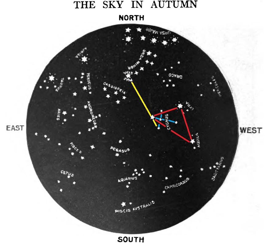
The Navigators Triangle”, the “Northern Cross” and the line through Deneb to the North Star, the colored lines have been added by the Author, the original, from Wikimedia, HERE.


The last option was D) to locate the Navigator’s Triangleand to plot true north from the brightest star in the triangle.


While Vega is the brightest star in the “Navigator’s Triangle”, and one of the brightest stars in the night sky, it cannot help you find the celestial north pole.  However, by finding the “Navigators Triangle”, you can find the “Northern Cross”, which can help you locate the North Star.


During the summer, when the “Navigator’s Triangle”3 is visible all night, at nightfall, look towards the east away from the direction of the setting Sun, and find Altair, which is to your right as you face east.  Then, to the left and up from Altair, by about 50o, or about a two hand-spans, which is twice the distance from the tip of your little finger to the tip of your thumb when your arm is fully extended, you will find Vega.  Once you have found Vega, look to your left and down by about a hand-span, or 25o, and you will find Deneb.  To complete the “Navigators Triangle”, look to your right by about two hand-spans, to return to Altair.


The “Northern Cross” connects Deneb, which is the tail of Cygnus the Swan, to Sadr and then to the star Albiero to make the vertical pole of a cross.  Then mentally draw a line from Gienah, on the left, through the star Sadr, and on to Rukh on the right, to complete the horizontal pole of the cross.


Once, you have found the “Northern Cross”, trace an imaginary line through the sky from Gienah, on the left of horizontal pole of the “Northern Cross”, through Deneb, which is located at the top of the “Northern Cross”, for about one hand-span, plus one fist or palm, or a about 35o, to find the North Star.


An excerpt from Earth and Sky Every Child Should Know, by J. E. Rogers, 1910, page 248, showing the “Navigators Triangle”, the “Northern Cross” and the line through Deneb to the North Star, the Author has added the colored lines5.


What did the Survival Experts choose?


So”, I ask, “what did you choose?  And did you choose the answer that the United States Air Force survival expert chose”?


The survival expert chose, B) find Polaris, the North Star, and orient your map with it.  Did you choose B)”, I wonder, “If so, you picked the right answer, if not, now you know the right answer”!


An excerpt from The Stars and Their Stories, 1913, by Alice Mary Matlock Griffith, page 258, the Author has added the colored lines


Don’t forget to come back next week and read “A Hudson Bay Start, A Pro-Tip! ©”, where we will talk about how to get a good start on your next wilderness adventure.


I hope that you continue to enjoy The Woodsman’s Journal Online and look for me on YouTube at BandanaMan Productions for other related videos, HERE.  Don’t forget to follow me on both The Woodsman’s Journal Online, HERE, and subscribe to BandanaMan Productions on YouTube.  If you have questions, as always, feel free to leave a comment on either site.  I announce new articles on Facebook at Eric Reynolds, on Instagram at bandanamanaproductions, and on VK at Eric Reynolds, so watch for me.


That is all for now, and as always, until next time, Happy Trails!


Notes


1 Although, according to Robert S. Owendoff, the author of Better Ways Of Pathfinding, if the Moon is bright enough to cast a distinct shadow you can use the shadow tip method to create an approximate east-west line from the light of the moon.  You can also use the movement of the stars or the Moon to find an approximate east-west line. 


2 From “Polaris: How to find the North Star”, by Vicky Stein, January 24, 2022.


3 Ibid.


4 For more on the “Navigator’s Triangle” read “The ‘Navigator’s Triangle’...What?©”, HERE.


5 Star maps can look confusing as they are not drawn in the normal manner, with west on the left side and with east on the right side of the map.  They are drawn so that they show the sky as it would appear if you were lying down, looking upwards, with your legs pointing south.  In that position as you looked at the night sky, east would be to your left and west on your right.


Sources


Matlock Griffith, Alice Mary; The Stars and Their Stories, [Henry Holt and Company, New York, 1913], pages 11 to 13, 41 to 42 and 258,

https://books.googleusercontent.com/books/content?req=AKW5QafNsnznDDr_ccnzzDmvLfOpEy0dyRJFFSw-vrvTdCcVJ-fourudq0Axrjg67fhYBEKkE-MwWXlROFtAr0hQKuImAVgqk2RboeJjiigLNW-ghhXU1u7ghhEl5OsDI8hnKKtM6x_sr74qSfzMAaDr6Zp7HAU67y-R-Ur0vtZUw9E77fJQb8SzbkpMHHzN1VfYAdnZqg4gyDYfcrloJSRUiv2p7xhvZDwrp7lkkLuEqI55ggMCvKPbPM-UIohHm9UE1WM5Qz7yGc_BT2lh48se7WdGhi3oVA, accessed July 11, 2022


Owendoff, Robert S.; Better Ways Of Pathfinding, [The Stackpole Company, Harrisburg, Pennsylvania, 1964], page 82 to 85


Rogers, Julia Ellen; Earth and Sky Every Child Should Know, [Doubleday, Page & Company, Garden City, New York, 1910], page 221, https://books.google.com/books?id=0TsIAAAAIAAJ&pg=PA240&dq=stars+of+the+northern+cross&hl=en&newbks=1&newbks_redir=0&sa=X&ved=2ahUKEwi-99rj4_34AhVZD1kFHTuTDNE4FBDoAXoECAQQAg#v=onepage&q=stars%20of%20the%20northern%20cross&f=false, accessed July 16, 2022


Spokane Daily Chronicle, “Could You Survive?”, Aug 30, 1977, page 8, https://books.google.com/books?id=fPpLAAAAIBAJ&pg=PA8&dq=%22spokane+daily+chronicle%22+%22could+you+survive%22&article_id=5769,3677539&hl=en&sa=X&ved=2ahUKEwi4l8qYkdv4AhUlMVkFHZQbB8MQ6AF6BAgDEAI#v=onepage&q=%22spokane%20daily%20chronicle%22%20%22could%20you%20survive%22&f=false, accessed July 6, 2022


Stein, Vicky; “Polaris: How to find the North Star”, January 24, 2022, [© Future US, Inc.], https://www.space.com/15567-north-star-polaris.html, accessed July 22, 2022


Woodland Ways Bushcraft Blog, “Star Lore 4”, [@ 2020 Woodland Ways Ltd.], https://www.woodland-ways.co.uk/blog/natural-navigation-tips/star-lore-4/, accessed July 7, 2022


Wikimedia, " Wide-field_view_of_the_Summer_Triangle modifié", by NASA, ESA; https://commons.wikimedia.org/wiki/File:Wide-field_view_of_the_Summer_Triangle_modifi%C3%A9.jpg, accessed July 7, 2022


Young, Ernest; Scales and direction, surveying, projections: A Rational Geography, Part III, [George Philip & Son, London, 1911], page 4, https://www.google.com/books/edition/Scales_and_direction_surveying_projectio/JJtIAQAAMAAJ?hl=en&gbpv=1&dq=draw+a+line+from+the+points+of+the+moon+to+find+south&pg=PA4&printsec=frontcover, accessed July 19, 2022


Sunday, July 17, 2022

The 'Navigator’s Triangle'...What?©


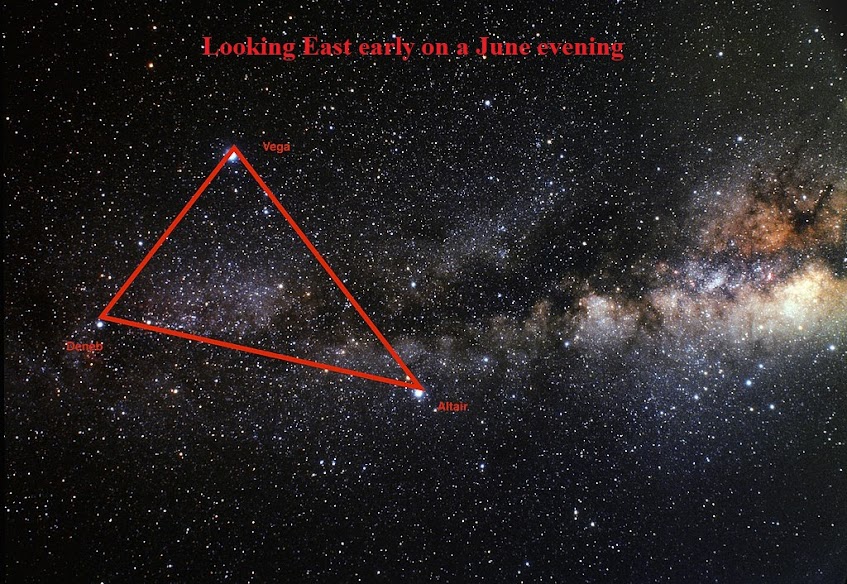
The “Navigator’s Triangle”, seen from the northern hemisphere, from Wikimedia, HERE.


A couple of weeks ago, I was reading a “Could You Survive” article written by one of the Air Force Survival experts and he talked about using the “Navigator’s Triangle” in the night sky to find north. 


Have you ever heard of the “Navigator’s Triangle”?  I never had, and I thought, “Cool, another way to use the stars to find north”!  So, I did what I always do, and did some research, and I found that it wasn’t just that simple.


An excerpt from The Stars and Their Stories, 1913, by Alice Mary Matlock Griffith, page 41.


The “Navigator’s Triangle” is also called the “Summer Triangle” and it is an asterism, or a pattern of stars smaller than a constellation, made by drawing lines between three of brightest stars in the night sky, each of which are part of other constellations.  Altair, in the constellation of Aquila; Deneb, in the constellation of Cygnus (also known as the “Northern Cross”) ; and Vega in the constellation of Lyra.  The “Navigators Triangle” is an imaginary, nearly isosceles triangle, which lies across the Milky Way.


An excerpt from The Stars and Their Stories, 1913, by Alice Mary Matlock Griffith, page 42, red lines added by the Author.


The “Navigator’s Triangle” is visible for most of the year in north of the equator,  During the spring it is visible in the eastern sky, early in the mornings; and on fall and winter evenings until January, it can be seen in the west.  But during the summer, it rises in the east at sunset, is directly overhead around midnight and sets at sunrise in the west, and this visibility is why it is also known as the “Summer Triangle”. 


This asterism can also be seen in the mid-southern latitudes, below the equator, where it will appear in the northern sky, above the horizon, upside down from how it would appear in the northern hemisphere.  In the southern hemisphere it is called the “Northern Triangle” or the “Winter Triangle1.


From “Measuring The Sky”, by Brian Ventrudo, April 19, 2009, HERE.  When fulling extending your arm, your fingers can measure degrees of distance.


To find the “Navigator’s Triangle”, during the summer, after sunset2, look east and locate Altair, which is to your right as you face east.  Then, to the left of Altair, and up in altitude, as you continue looking east, by about a two hand-spans (which measure the distance from the tip of your little finger to the tip of your thumb, when your arm is fully extended), or about 50o, you will find Vega.  Once you have found Vega, look down and a little further to your left, about a hand-span, or 25o, and you will find Deneb.  To complete the “Navigators Triangle”, look to your right as you continue looking east, by about two hand-spans to return to Altair.


The “Navigator’s Triangle”, seen from the northern hemisphere, modified by the Author, the original, from Wikimedia, HERE.


Now, before we go any further, a quick note on star maps is in order, since they can look confusing as they are not drawn in the normal manner, with west on the left side and with east on the right side of the map.  They are drawn so that they show the sky as it would appear if you were lying down, looking upwards, with your legs pointing south.  In that position as you looked at the night sky, east would be to your left and west on your right.


An excerpt from Earth and Sky Every Child Should Know, by J. E. Rogers, 1910, page 248, showing the “Navigators Triangle”, the Author has added the colored lines.


Now unfortunately, the “Navigator’s Triangle” cannot directly tell you where north is, however, it can help you find the “Northern Cross” and once you have found that, then you can find the North Star.  And the good news is, that the stars of the “Navigators Triangle” are so bright that they can be seen even in a sky polluted with the lights of a city. 


An excerpt from Earth and Sky Every Child Should Know, by J. E. Rogers, 1910, page 221.


The “Northern Cross” is drawn by connecting Deneb, which is the tail of Cygnus the Swan, to Sadr and then to the star Albiero to make the long pole of the cross.  Then draw a line from Gienah on the left of the cross piece, through the star Sadr, and on to Rukh on the right, to complete the cross piece.


The “Navigators Triangle” and the “Northern Cross”, the colored lines have been added by the Author, the original, from Wikimedia, HERE.

An excerpt from Earth and Sky Every Child Should Know, by J. E. Rogers, 1910, page 248, showing the “Navigators Triangle” and the “Northern Cross”, the Author has added the colored lines.


Now that, you have found the “Northern Cross”, trace an imaginary line through the sky from Gienah, on the left of the cross piece of the “Northern Cross”, through Deneb, which is located at the top of the “Northern Cross”, for about one hand-span, plus one fist or palm, or about 35o, to find the North Star.


The Navigators Triangle”, the “Northern Cross” and the line through Deneb to the North Star, the colored lines have been added by the Author, the original, from Wikimedia, HERE.

An excerpt from Earth and Sky Every Child Should Know, by J. E. Rogers, 1910, page 248, showing the “Navigators Triangle”, the “Northern Cross” and the line through Deneb to the North Star, the Author has added the colored lines.


So now you know the how to use the “Navigators Triangle”, to find the “Northern Cross” and then the North Star.


Don’t forget to come back next week and read “Could you survive?  The Moon, the Stars, and the Navigators Triangle ©”, where we will discuss what the United States Air Force survival experts had to say about using the night sky to find your directions.


I hope that you continue to enjoy The Woodsman’s Journal Online and look for me on YouTube at BandanaMan Productions for other related videos, HERE.  Don’t forget to follow me on both The Woodsman’s Journal Online, HERE, and subscribe to BandanaMan Productions on YouTube.  If you have questions, as always, feel free to leave a comment on either site.  I announce new articles on Facebook at Eric Reynolds, on Instagram at bandanamanaproductions, and on VK at Eric Reynolds, so watch for me.


That is all for now, and as always, until next time, Happy Trails!


Notes


1 From “Touring the Summer Triangle”, by Brian Ventrudo, July 3, 2015


2 Remember, during the spring the “Navigator’s Triangle” is visible in the eastern sky, early in the morning, and in the western sky on fall and winter evenings until January.  During the summer, it rises in the east at sunset, will be directly overhead around midnight and it will set at sunrise in the west.


Sources


“Calculating Sunset Time With Your Fingers”, http://awesci.com/calculating-sunset-time-with-your-fingers/, (accessed 11/27/18)


Matlock Griffith, Alice Mary; The Stars and Their Stories, [Henry Holt and Company, New York, 1913], pages 11 to 13, 41 to 42 and 258,

https://books.googleusercontent.com/books/content?req=AKW5QafNsnznDDr_ccnzzDmvLfOpEy0dyRJFFSw-vrvTdCcVJ-fourudq0Axrjg67fhYBEKkE-MwWXlROFtAr0hQKuImAVgqk2RboeJjiigLNW-ghhXU1u7ghhEl5OsDI8hnKKtM6x_sr74qSfzMAaDr6Zp7HAU67y-R-Ur0vtZUw9E77fJQb8SzbkpMHHzN1VfYAdnZqg4gyDYfcrloJSRUiv2p7xhvZDwrp7lkkLuEqI55ggMCvKPbPM-UIohHm9UE1WM5Qz7yGc_BT2lh48se7WdGhi3oVA, accessed July 11, 2022


Newquist, Susan; “Let Your Fingers Tell Time”, July 31, 2000, https://www.backpacker.com/skills/let-your-fingers-tell-time, (accessed 11/27/18)


Rogers, Julia Ellen; Earth and Sky Every Child Should Know, [Doubleday, Page & Company, Garden City, New York, 1910], page 221, https://books.google.com/books?id=0TsIAAAAIAAJ&pg=PA240&dq=stars+of+the+northern+cross&hl=en&newbks=1&newbks_redir=0&sa=X&ved=2ahUKEwi-99rj4_34AhVZD1kFHTuTDNE4FBDoAXoECAQQAg#v=onepage&q=stars%20of%20the%20northern%20cross&f=false, accessed July 16, 2022


Ventrudo, Brian; “Measuring The Sky”, April 19, 2009, https://oneminuteastronomer.com/860/measuring-sky/, (accessed 11/27/18)


Ventrudo, Brian; “Touring the Summer Triangle”, July 3, 2015, [© 2022 Mintaka Publishing Inc.], https://cosmicpursuits.com/245/touring-the-summer-triangle/, accessed July 14, 2022


Wikimedia, " Wide-field_view_of_the_Summer_Triangle ", by NASA, ESA; https://commons.wikimedia.org/wiki/File:Wide-field_view_of_the_Summer_Triangle.jpg, accessed July 7, 2022


Wikimedia, " Wide-field_view_of_the_Summer_Triangle modifié", by NASA, ESA; https://commons.wikimedia.org/wiki/File:Wide-field_view_of_the_Summer_Triangle_modifi%C3%A9.jpg, accessed July 7, 2022