Pages

Pages

Sunday, June 30, 2019

“Soaping Your Pot”: The Oelslager Files, Part Three ©


Figure 186, p. 54, Bushcraft, Scoutcraft & Woodlore, Vol. II, by Dr. R. W. Oelslager

There you are, out in the woods, by a fire, boiling a pot of water.  Your pot turns black with a layer of soot and when the fire is out and you want to pack the pot away, the soot rubs off onto everything, your hands, your pack, and your clothes and yet you can’t seem to scrub it all the way off the pot. 

During the late 18th and early 19th centuries, camp kettles were carried in linen bags with slings or “cases”, in order to keep soot and grease off your clothes and to make the camp kettle easier to carry1.  However by the early 1960s, a new wrinkle or camp hack had appeared, soaping your pots to prevent the soot from sticking to them.  I did a quick bit of research and the earliest record of this particular wrinkle that I could find, was first published in Bill Riviere’s The Campers Bible, in 1961.


The Campers Bible, Revised Edition, by Bill Riviere, Doubleday & Company, Inc. Garden City, NY, 1970


Rubbing soap on the outside of a utensil will make the soot much easier to remove when washing… Rub the paste on the pot or kettle on the pot or kettle before using over an open fire and when you wash the utensil, the soot will almost float away
The Campers Bible, by Bill Riviere, 1961

This camp trick was one of the first things I learned when I joined Boy Scout Troop 131, out of Lakewood, NY, in 1976 and it was also taught by Doc Oelslager, who recorded it on page 54 of his book Bushcraft, Scoutcraft & Woodlore, Vol. II.  I still use this bit of campcraft today. 

Oh and this is very important, when you teach someone else this, be very clear that the soap ONLY goes on the outside of the pan.  Apparently, I wasn’t very clear when I was teaching this to someone in 1976, and, well, the SPAM® was well spiced with Dawn® dish soap.  It is amazing what you will eat when you are really hungry!


I hope that you have enjoyed this installment of the Oelslager Files, highlighting the writings and research of Robert William “Doc” Oelslager.  For more Oelslager Files, see “The Oelslager Files”, HERE and “Estimating The Time Till Sunset”, HERE.

Don’t forget to follow me on The Woodsman’s Journal Online and subscribe to BandanaMan Productions on YouTube, and if you have questions, as always, feel free to leave a comment on either site.


Notes

1  Rees, John U., "Properly fixed upon the Men..." Linen Bags for Camp Kettles

Sources

Oelslager, Dr. R. W., Bushcraft, Scoutcraft & Woodlore, Vol. II, Figure 186, [privately published] p. 54

Rees, John U., "Properly fixed upon the Men..." Linen Bags for Camp Kettles, The Brigade Dispatch (Journal of the Brigade of the American Revolution), Vol. XXVII, no. 3 [Autumn 1997], p. 2-5, http://revwar75.com/library/rees/kettlebags.htm, accessed June 22, 2019

Riviere, Bill, The Campers Bible, Revised Edition, [Doubleday & Company, Inc. Garden City, NY, 1961] p. 97


Sunday, June 23, 2019

Thank You to All My Readers


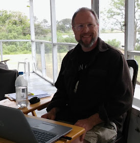
The author writing a post while in Deep Creek, VA.  Picture by the author.

  
It has been an exciting six months here at The Woodsman’s Journal Online, and I would like to take a moment to thank all of my readers for their support.  Thank you!  The Woodsman’s Journal Online is growing and we have surpassed 1,000 page views during the last month, so thank you again for all of your support.

I thought it would be fun to imagine being interviewed and answer the questions; I thought I would be asked.

Why did you call your blog, The Woodsman’s Journal Online?

During the late 80s and early 90s, I use to enjoy reading “fanzines” and other home-based magazines and newsletters, which had been written, typed and printed in someone’s kitchen, before being put into the U.S. Mail for distribution.  Fast forward to 2018, when I started The Woodsman’s Journal Online, as much as possible I wanted my blog to be similar to those “zines” from the 80s and 90s that I had enjoyed so much.  Obviously, the internet has radically changed every aspect of life in the modern world, and home-based publishing is no exception: everything is now faster, quicker and much, much easier!  It is hard to believe how much easier and faster it is today to research, type, publish and distribute your home-based magazine: no more cutting, pasting and photocopying pictures to create graphics.  Today the world is your oyster and you don’t need the U.S. Mail!  So the name, The Woodsman’s Journal Online, is a nod to all of those home-based “zines” of the 80s and 90s and with a wink at our ever expanding, worldwide, online culture.

Oh and I find that I do some of my best writing while I am sitting at the kitchen table.

“In your videos you call yourself The BandanaMan, why?”

There are two parts to that answer; first, as I have gotten older I have found that I have grown past my hairline.  I hate getting sunburned on the top of my head, about as much as I hate getting bitten by bugs there; and so, I always wear something on my head when I am in the woods.  Sometimes, when I am canoeing or hiking, I wear a brimmed hat, but I find it difficult to wear a brimmed hat when I am carrying a large pack or portaging a canoe, and so I usually wear a bandana tied around my head.


A picture of the author wearing his usual headgear, picture by the author.


And for the second part, in 2015 I taught a Birchbark Expeditions Shakedown class to a group of scouts, who I later met in Algonquin Park as they were coming off the water and finishing their trek.  One of the boys said to me, as I was uncharacteristically NOT wearing a bandana, “Hey! I know you, you are the bandana man”.  This is why I call myself BandanaMan and why I named my YouTube channel BandanaMan Productions.

“How and when did you become interested in the outdoors, bushcraft, survival and the history of the Old Northwest Frontier?”

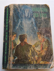
I have always been interested in the outdoors, and when my brother, sister, and I were little, my parents took us tent camping often.  My favorite book, even before I could read, was my Father’s 1953 edition of the Boy Scout, Handbook For Boys.  I used to get up at first light, and during the summer, I would take this book off my Father’s bookshelf, take it to my tree fort and look at the pictures.  Later in July 1978, I went to Algonquin Provincial Park for the first time, with Boy Scout Troop 131, see “…First Time In Algonquin…” found HERE.  While I was there I became fascinated with wilderness survival, in fact when we stopped at Algonquin Outfitters to buy souvenirs, I bought my first two wilderness survival books: Wilderness Survival, by Berndt Berglund and Survival in the Wilderness, by Life Support Technology, Inc.

  
The Handbook For Boys, June 1953, Fifth Edition – Sixth Printing, by Boy Scouts Of America.  Picture by the author. 

Wilderness Survival, by Berndt Berglund, picture by the author.

  
Survival in the Wilderness, by Life Support Technology, Inc., picture by the author.


I have always been fascinated by American history, having heard tales of my Great Grandfather6 Daniel Ogden, who was a scout and a ranger in the Tryon County militia and his son, David, who was captured by Joseph Brant, who had been a family friend before the war, near Fort Stanwix, NY and marched to Fort Niagara, NY.  When I was about 16 years old, at a garage sale, I bought a copy of The Frontiersmen, by Allan Eckert, and from then on I was hooked and I have wanted to learn everything I could about life on the Old Northwest Frontier of the late 18th and early 19th centuries.  In addition, when my oldest son turned eleven, we went to Fort Niagara to see a reenactment of the fort being captured from the French by the English.  He loved it!  He thought it was adults playing dress up, which in some ways it is, what he didn’t understand then, was how much research and learning is required to portray, accurately, what life was like 250 years ago.  He didn’t understand this, but I did and since I said I would help him with this, I dove even deeper into the world of the late 18th and early 19th centuries, specifically the history of what is today the northeastern United States.


Captive! The story of David Ogden and the Iroquois, picture by the author.


The Frontiersmen, by Allan Eckert, picture by the author.


“Why, when you are writing about history, do use really old sources, instead of more modern one?”

The answer to this question also has two parts.  First, I always try to use sources that are close to or current with the time I am writing about, so that I can understand how people of that time thought and acted.  Also, whenever I can, I try to use sources that were written by people who lived through an event that I am writing about: these type of sources are called ‘primary’ sources.  Primary sources are better than ‘secondary’ sources, which were written by people, usually a long time afterwards, who didn’t actually do the thing they wrote about or live through the event in question.  As Christian Cameron noted “reading primary sources is research … reading secondary sources is learning1.  These two distinctions are very important to me, since my mission for both The Woodsman’s Journal Online and BandanaMan Productions is to be the best researched resource available to the online user (for more on this see “The End of 2018 and the Beginning of 2019” HERE).

I hope that you continue to enjoy The Woodsman’s Journal Online and my videos at BandanaMan Productions and thank you again for reading and watching my content. 

Don’t forget to follow me on The Woodsman’s Journal Online and subscribe to BandanaMan Productions on YouTube, and if you have questions, as always, feel free to leave a comment on either site.

Sources

1  The European Experience of Partisan Warfare, A Treatise for the Fort Ticonderoga Command Conference, March, 2008, Christian Cameron, https://www.academia.edu/839474/The_Eurpean_experience_of_Partisan_Warfare--a_lecture_for_the_NAM_Chelsea, accessed 6/15/19


Sunday, June 16, 2019

Conch Shell Trumpet ©


The author blowing a conch-shell trumpet, picture by the author


 On the Old Northwest Frontier of the late 18th and early 19th centuries, a trumpet made by removing the tip of a conch shell, was a commonly used for signaling by both the Native Americans and the European Settlers.


From “The Use Of Shells By Ontario Indians”, by W. J. Wintemberg  p. 46 and p. 62


The author of “The Use Of Shells By Ontario Indians”, W. J. Wintemberg, reprints the assertion by Dr. Beauchamp that “Shell trumpets were not used by N.Y. Indians in the early days – at least not in the interior, but that there is a record of their use in 17911.  As evidence of this, Dr. Beauchamp used Col. Thomas Proctor’s journey from Buffalo Creek (today’s Buffalo, NY) via Fort Franklin (Franklin, PA) and Fort Pitt (Pittsburgh, PA), before arriving at Philadelphia, PA.
Regarding the use of conch shell trumpets, Col. Proctor wrote the following in his journal, near today’s Warren PA: “April 19th [1791] – O’Beel [John Abeel III or Cornplanter] and chiefs arrived here from the lower town and ordered their conch shell to be sounded through the village to summon their head-men into council2.

Additionally, Col. Proctor wrote on the “24th [June, 1791 at New Arrow’s Town, near today’s Warren, PA] I had no sooner arrived then the chiefs were summoned to council by the sound of a conch shell…3.

Contrary to Dr. Beauchamp’s assertion that there is no evidence of conch shell trumpets being used by Native Americans in the interior of New York and Pennsylvania before 1791, there is evidence that predates 1791.   John Woolman, writing from “Wehaloosing” (today’s Wyalusing, PA), recorded in his journal on June 17th, 1763, the following:

After a while we heard a conk-shell blow several times, and then came John Curtis, and another Indian man…4.

There is also evidence of conch shell trumpets being used by colonial settlers in southwestern Pennsylvania before 1791.  In 1764, John Minor, who was originally from London County, Virginia, settled in what is now Mapletown, PA, west of the Monongahela River, on Dunkard Creek.  By 1778, his cabin was fortified and he kept a “huge conch shell”, that was blown in times of danger, and which still existed in 1888, when the History of Greene County, Pennsylvania was printed.5

In addition, European Settlers used conch shell trumpets on the western frontier of New York State, along the Mohawk River and its tributaries, during the American Revolution.  David Elerson, writing about the rangers, in Frontiersman of New York, noted that “…The music of those scouts, was produced by a conch-shell, which was carried by the leader, and served to call the party together when they chanced to become separated in the woods”.6

The evidence shows that conch shell trumpets were used for signaling after the French and Indian War and during the American Revolutionary War, by both the Native Americans and the European militia and rangers of the Old Northwest Frontier during the late 18th and early 19th centuries.


Conch shell trumpet, picture by the author

Conch shell trumpet, picture by the author

Conch shell trumpet, picture by the author

  
However, as a reenactor, how do you make a conch shell into a trumpet and once it is made, how do you use it?

First, I have never made a conch shell trumpet, the one that I used in these photos and videos had already been made into a horn.  However, I did a little research and found out that turning a conch shell into a trumpet is really quite simple.  All you have to do is remove the tip of the whorl, of a queen or pink conch shell [Lobatus gigas, originally known as Strombus gigas], to make a mouth piece, remove the inner spiral to open the airway and nature has made the rest of the trumpet for you.  For some web sites on how to do this go [HERE] and [HERE].

For those who would rather have the instructions in print, here are some “how-to-do-its” from these two videos.  First, you have to have a conch shell to make a trumpet.  Wash out your shell thoroughly and then soak it overnight in a 10% bleach solution7; rinsing it with water in the morning.  You will want one that is at least six or seven inches long.  If you get one that has been commercially harvested for meat, it will have a hole around the fourth spiral; you will have to plug this hole either with epoxy or with your finger when you play the conch shell.

Next, saw or break the tip off the shell, so that there is a small opening about the size of a US dime, this will be the mouthpiece.  Depending on the size of your shell, you will have to remove around 1” to 1¼” of the tip to make a dime-sized hole. 


Close-up of the mouthpiece of a conch shell trumpet, note the removal of the inner spiral, picture by the author


Remove the inner spiral inside the mouthpiece with a drill, a nail or a center punch, in order to open an airway into the shell.

Lastly, to keep from cutting your lips, smooth the edges with a file or medium grit sandpaper.

You play a trumpet by blowing air through nearly closed lips, making a buzzing sound, and creating a standing wave vibration in the air inside the trumpet.  This vibration inside the conch shell is what creates the trumpeting sound at the aperture or opening of the shell.

 Making the buzzing sound with your lips to blow a conch shell trumpet, video by the author

So if you are a modern reenactor or experimental archeologist, who is portraying either Native Americans or European militia and rangers in central and western Pennsylvania and New York during the late 18th and early 19th centuries, blow that conch shell trumpet! 


 The author blowing a conch shell trumpet, video by the author


For a short video that I made on this subject go [HERE]


Notes

1  W. J. Wintemberg; “The Use Of Shells By Ontario Indians”, Annual Archeological Report, 1907, [L.K. Cameron. Toronto, Ontario; 1908], p. 61

2  Proctor, Col. Thomas; “Col. Proctor’s Journal”, Pennsylvania Archives, Second Series, Vol. IV, Edited by John B. Linn and William H. Egle, M.D. [E.K. Meyers, Harrisburg, 1890] p. 485

3  Ibid., p. 511

4  A Journal of The Life And Travels of John Woolman, Third Edition [The School if Industry, Lindfield, 1838], p. 204

5  Bates, Samuel P.; History of Greene County, Pennsylvania [Nelson, Rishforth & co., Chicago, 1888], p. 520-521

6  Simms, Jeptha Root; The Frontiersman of New York: Showing Customs of the Indians, Vol. 2, [Geo. C. Riggs, Albany, NY, 1883], p. 413

7  “To make a 1:10 solution, you'll need 1 part bleach for every 9 parts water. A good amount to start with is 1/4 cup bleach and 2¼ cups of water.” Carefully pour the bleach into the bucket first, and then add the water.”  From “How to Make Your Own Disinfectant Bleach Solution - Verywell Health”, Sep 22, 2018


Sources


Bates, Samuel P.; History of Greene County, Pennsylvania [Nelson, Rishforth & co., Chicago, 1888], p. 520-521 https://books.google.com/books?id=nx5EAQAAMAAJ&pg=PA520&dq=pennsylvania+conch+shell&hl=en&sa=X&ved=0ahUKEwj9nIWar8biAhUyTd8KHfWNBmI4oAEQ6AEITjAH#v=onepage&q=pennsylvania%20conch%20shell&f=false, accessed May 30, 2019

Conch Shell Horn, https://www.instructables.com/id/Conch-Shell-Horn/, accessed 6/11/19

How to Make a Conch Shell Horn, https://www.youtube.com/watch?v=ebzN79oNTJg, accessed 6/11/19

How to Make Your Own Disinfectant Bleach Solution - Verywell Health, Sep 22, 2018 https://www.verywellhealth.com/make-your-own-disinfectant-solution-998274, accessed 6/14/19

Lobatus gigas, https://en.wikipedia.org/wiki/Lobatus_gigas, accessed 6/11/19

Proctor, Col. Thomas; “Col. Proctor’s Journal”, Pennsylvania Archives, Second Series, Vol. IV, Edited by John B. Linn and William H. Egle, M.D. [E.K. Meyers, Harrisburg, 1890] p. 485 https://books.google.com/books?id=JT8OAAAAIAAJ&pg=PA485&dq=pennsylvania+conch+shell&hl=en&sa=X&ved=0ahUKEwiT2-2QrcbiAhUhWN8KHYmrAJE4qgEQ6AEIRTAF#v=onepage&q=pennsylvania%20conch%20shell&f=false, accessed May 30, 2019

Simms, Jeptha Root; The Frontiersman of New York: Showing Customs of the Indians, Vol. 2, [Geo. C. Riggs, Albany, NY, 1883], p. 413 https://books.google.com/books?id=ZxobAAAAYAAJ&pg=PA413&dq=indian+ranger+conch+%22new+york%22&hl=en&sa=X&ved=0ahUKEwjQ_-umz8biAhVCMt8KHYfQBfk4KBDoAQhAMAU#v=onepage&q=indian%20ranger%20conch%20%22new%20york%22&f=false, accessed May 30, 2019

Trumpet, https://en.wikipedia.org/wiki/Trumpet, accessed 6/11/19

Wintemberg, W. J.; “The Use Of Shells By Ontario Indians”, Annual Archeological Report, 1907, [L.K. Cameron. Toronto, Ontario; 1908], p. 61 https://books.google.com/books?id=m2jRoqWJm_0C&printsec=frontcover#v=onepage&q&f=false, accessed May 30, 2019


Sunday, June 9, 2019

The Madawaska River Loop: Whitefish, to Pen, to Harry and Louisa…And Back Again! Part One ©


Pen Lake in the Morning, 2014.  Picture by the author.


This August, I am guiding eight members of Boy Scout Troop 628 on a Birchbark Expedition's trek (for information on Birchbark Expeditions, go HERE) on the Madawaska River loop.


Map of the Madawaska River watershed, arrows indicate the direction of water flow.  From “19th Century Aboriginal Farmers of the Madawaska River”, by Bill Allen, Figure 1


The Madawaska River is the largest tributary of the Ottawa River, rising in Ontario.  The Madawaska River is made up of three tributaries that each drain a series of lakes within Algonquin Park, before flowing into Rock Lake and then into Galeairy Lake.  The South Madawaska flows from Madawaska Lake through the South Madawaska River to Clydegale Lake to Pen Lake and into Rock Lake, while the North Madawaska River drains southward to Rock Lake from Source Lake, Cache Lake, Lake of Two Rivers and Whitefish Lake.  The main branch of the Madawaska River rises near Manitou Mountain, by the boundary of the Georgian Bay watershed and flows eastward into Head Creek, Lake Louisa, and Louisa Creek before emptying into Rock Lake.


Loons, things that you can see in the Madawaska River watershed, picture by the author.

Beaver lodge, things that you can see in the Madawaska River watershed, picture by the author.

  
We will be putting in at Whitefish Lake and canoeing to Pen on day one.   On day two, they will be traveling from Pen Lake to Harry Lake; day three, canoeing from Harry Lake to Lake Louisa; day four, travelling from Lake Louisa to Head Lake; and finally on day five, canoeing from Head Lake down the North Madawaska River into the Lake of Two Rivers, then back again to Whitefish Lake.  The total distance traveled will 56.6 miles of canoeing and portaging.  This is a great route, and I thought I would put together travel-log: if you take this route, this is what you might see.


Red lines indicate the travel route, from Jeff’s Map, Wall Map Version 5.0, annotated by the author.  


Along the cliffs on the west side of Rock Lake, just within Picto-Bay, there are two Native American pictographs (painted symbols) in faded red paint on the cliff wall, only reachable by canoe.  They were most likely painted hundreds of years ago, by the Algonkian speaking Nipissings, and today you can still see a human figure with horns, what archeologists call an “anthropomorph”, and nearby three vertical slashes.  The three vertical slashes might once have been joined by a horizontal curved line, to represent three men in a canoe, a common Native American pictograph.
  
Where to find the pictographs in Picto-bay on Rock Lake, picture by the author

Where to find the pictographs in Picto-bay on Rock Lake, noted, picture by the author

Pictograph of a human figure with horns, picture by the author


Pictograph of three slashes, picture by the author

On top of the cliff, above the lake, before Picto-bay, are what the archeologists call the “dream pits”.  They are on the west side of Rock Lake, on the opposite side of the lake from Booth’s Rock Trail.  Some archeologists believe that these pits are where Native American youths would go to fast and pray for spiritual guidance.  However, Bill Allen, who wrote “Nineteenth Century Aboriginal Farmers of the Madawaska River”, suggested that they might actually be root cellars or equipment caches, as the dimensions of the “dream pits” are similar to those from known 19th century farm sites, one on Rock Lake and one on Galeairy Lake.

You have to hike Booth’s Rock Trail, and see the remains of J.R. Booth’s palatial estate, which can be seen from the trail.  This three-mile trail loop is a fantastic side trip; it offers fantastic views, from the top of the cliff, of the lake below -- don’t miss it.
  
View from the top of Booth's Trail, picture by the author

View from the top of Booth's Trail, picture by the author


Red lines indicate the travel route, from Jeff’s Map, Wall Map Version 5.0, annotated by the author.  


The spring along the Rock Lake to Pen Lake portage, picture by the Author

On the Rock Lake to Pen Lake portage, there is a spring on the west side portage, near the Rock Lake side of the portage.  The water flows from a black pipe near the trail and it is potable, refreshing and very cold.

The water falls between Pen Lake and Rock Lake.  Picture by the author.
  
From “Vision Pits, Cairns and Petroglyphs at Rock Lake” by William C. Noble, p. 48

From “Vision Pits, Cairns and Petroglyphs at Rock Lake” by William C. Noble, p. 60

From “Vision Pits, Cairns and Petroglyphs at Rock Lake” by William C. Noble, p. 61

  
There are petroglyphs, Native American rock carvings, on both the west side and the east side of the river leading from Pen Lake to Rock Lake.  I wasn’t able to find the petroglyphs shown in “Vision Pits, Cairns and Petroglyphs at Rock Lake”, but we did find what we thought might be a petroglyph pecked into the side of a boulder on the west side of the portage facing the river.  It is 167 paces (left foot to left foot) from the Rock Lake side of the portage and 35 paces away from the portage trail.  The petroglyphs found on this portage may represent a “walking snake” and a stylized form of a “thunderbird (rock 1 and rock 3).

Maybe a petroglyph, picture by the author

Maybe a petroglyph, a close-up, picture by the author


There is an excellent campsite on Pen Lake, just past the end of the portage where the lake narrows.  On the western island, which is connected to the shore with a sandbar, are two campsites: they are excellent, the sites are flat, relatively bug free, have a nice beach and fresh water mussels.  In 2015, these two sites shared a luxury “thunder-box” (latrine) with walls, a roof and a door – it is practically the Hilton!  Also, when I was there in 2015, I saw the tracks of a yearling moose and a red fox on the sandbar; they were only, at most, only a couple hours old: we just missed them!
  
Our 2015 campsite on the island in Pen Lake, picture by author.

  
The moose tracks were approximately 3-7/8” long, indicating a yearling moose made them, and the red fox tracks measure 1-7/8” long, picture by the author.


Red lines indicate the travel route, from Jeff’s Map, Wall Map Version 5.0, annotated by the author.  


On the north shore of Lake Louisa, on a point bounded by Martin Creek and the outlet from Miller’s Lake, opposite the inlet that leads to Pondweed Lake, is a campsite where I found an old “blazed” pine tree stump.  You could tell in 2015, that the tree had survived being “blazed”, since it has begun to regrow the bark around the blaze.  Also, you could see that it had survived a forest fire with only a little charring around the roots.  The “blaze” was most likely a navigational aid when this area was logged, since near the base of the stump we found an old piece of a cast iron stove (in the picture this piece of iron is on top of the stump).

The “blazed” stump found near a campsite on the north shore of Lake Louisa, picture by the author.

A drawing made in 2015 of the “blazed” stump found near a campsite on the north shore of Lake Louisa, drawing by the author.
  
The portage from Rod& Gun Lake to Lawrence Lake is called the “Stairway to Heaven”.  In 2015, when I was there last, one of the scouts, who rarely said more than ten words in a day, used up five of his daily words, when he said “I don’t like this one…”.

Off to the side of the Pardee to Harness Lake portage are natural water slides.  They are a blast!  If you can arrange to eat lunch while on this portage, you can enjoy this natural playground.


Red lines indicate the travel route, from Jeff’s Map, Wall Map Version 5.0, annotated by the author.  
  
In 2014, when we got to Lake of Two Rivers, there was a strong northwesterly wind, so we decided to try a hand at sailing.  Since we had only two canoes, the middle paddlers held the canoes together, the front paddlers held onto the canoe paddle mast and to the bottom “halyards”, actually the corner tie-downs of the tarp.  The tarp center was tied to the paddle mast and the two top corner tie-downs became the top “halyards” which were tied to the rear thwart.  We flew down this lake, it was a lot of fun, however you have to be very careful to not capsize as the two canoes wanted to fold up like a clamshell, around the inside gunwales.


Drawing by the author

Drawing by the author


I hope that you take the Madawaska River loop someday and I hope that you enjoyed my travel-log of the sights that you might see if you do.

Sources:

Allen, Bill; “Nineteenth Century Aboriginal Farmers of the Madawaska River”, Partners to the Past: Proceedings of the 2005 Ontario Archaeological Society Symposium, edited by James S. Molnar [The Ottawa Chapter of the Ontario Archaeological Society, 2007], http://www.ottawaoas.ca/Symposium/Allen.pdf, Accessed July 16, 2015


Jeff’s Map, Wall Map Version 5.0, http://www.algonquinmap.com/, Accessed June 6, 2014

Murie, Olaus J., Roger Tory Peterson Field Guide: Animal Tracks, [The Easton Press, Norwalk, Connecticut, 1974]

Noble, William C.; “Vision Pits, Cairns and Petroglyphs at Rock Lake, Algonquin Provincial Park, Ontario”, [April 12, 1968] https://www.ontarioarchaeology.org/Resources/Publications/oa11-5-noble.pdf, Accessed July 16, 2015