 |
Pen Lake in the Morning, 2014. Picture by the author.
|
This August, I am guiding eight members of Boy Scout
Troop 628 on a Birchbark Expedition's trek (for information on Birchbark
Expeditions, go HERE) on the Madawaska River loop.
 |
Map of the Madawaska River watershed, arrows indicate
the direction of water flow. From “19th
Century Aboriginal Farmers of the Madawaska River”, by Bill Allen, Figure 1
|
The Madawaska River is the largest tributary of the
Ottawa River, rising in Ontario. The
Madawaska River is made up of three tributaries that each drain a series of lakes
within Algonquin Park, before flowing into Rock Lake and then into Galeairy
Lake. The South Madawaska flows from Madawaska
Lake through the South Madawaska River to Clydegale Lake to Pen Lake and into
Rock Lake, while the North Madawaska River drains southward to Rock Lake from
Source Lake, Cache Lake, Lake of Two Rivers and Whitefish Lake. The main branch of the Madawaska River rises
near Manitou Mountain, by the boundary of the Georgian Bay watershed and flows
eastward into Head Creek, Lake Louisa, and Louisa Creek before emptying into
Rock Lake.
 |
Loons, things that you can see in the Madawaska River
watershed, picture by the author.
|
 |
Beaver lodge, things that you can see in the Madawaska River
watershed, picture by the author.
|
We will be putting in at Whitefish Lake and canoeing to
Pen on day one. On day two, they will
be traveling from Pen Lake to Harry Lake; day three, canoeing from Harry Lake
to Lake Louisa; day four, travelling from Lake Louisa to Head Lake; and finally
on day five, canoeing from Head Lake down the North Madawaska River into the
Lake of Two Rivers, then back again to Whitefish Lake. The total distance traveled will 56.6 miles
of canoeing and portaging. This is a
great route, and I thought I would put together travel-log: if you take this route,
this is what you might see.
 |
Red lines indicate the travel route, from Jeff’s Map,
Wall Map Version 5.0, annotated by the author.
|
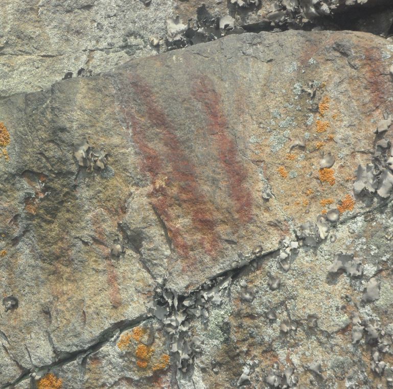
Along the cliffs on the west side of Rock Lake, just
within Picto-Bay, there are two Native American pictographs (painted symbols)
in faded red paint on the cliff wall, only reachable by canoe. They were most likely painted hundreds of
years ago, by the Algonkian speaking Nipissings, and today you can still see a
human figure with horns, what archeologists call an “anthropomorph”, and nearby
three vertical slashes. The three
vertical slashes might once have been joined by a horizontal curved line, to
represent three men in a canoe, a common Native American pictograph.
 |
Where to find the pictographs in Picto-bay on Rock
Lake, picture by the author
|
 |
Where to find the pictographs in Picto-bay on Rock
Lake, noted, picture by the author
|
 |
Pictograph of a human figure with horns, picture by
the author
|
 |
Pictograph of three slashes, picture by the author
|
On top of the cliff, above the lake, before Picto-bay,
are what the archeologists call the “dream pits”. They are on the west side of Rock Lake, on
the opposite side of the lake from Booth’s Rock Trail. Some archeologists believe that these pits
are where Native American youths would go to fast and pray for spiritual
guidance. However, Bill Allen, who wrote
“Nineteenth Century Aboriginal Farmers of the Madawaska River”, suggested that
they might actually be root cellars or equipment caches, as the dimensions of
the “dream pits” are similar to those from known 19th century farm
sites, one on Rock Lake and one on Galeairy Lake.
You have to hike Booth’s Rock Trail, and see the
remains of J.R. Booth’s palatial estate, which can be seen from the trail. This three-mile trail loop is a fantastic
side trip; it offers fantastic views, from the top of the cliff, of the lake
below -- don’t miss it.
 |
View from the top of Booth's Trail, picture by the author
|
 |
View from the top of Booth's Trail, picture by the author
|
 |
Red lines indicate the travel route, from Jeff’s Map,
Wall Map Version 5.0, annotated by the author.
|
 |
The spring along the Rock Lake to Pen Lake portage,
picture by the Author
|
On the Rock Lake to Pen Lake portage, there is a
spring on the west side portage, near the Rock Lake side of the portage. The water flows from a black pipe near the
trail and it is potable, refreshing and very cold.
 |
The water falls between Pen Lake and Rock Lake. Picture by the author.
|
 |
From “Vision Pits, Cairns and Petroglyphs at Rock Lake”
by William C. Noble, p. 48
|
 |
From “Vision Pits, Cairns and Petroglyphs at Rock Lake”
by William C. Noble, p. 60
|
 |
From “Vision Pits, Cairns and Petroglyphs at Rock Lake”
by William C. Noble, p. 61
|
There are petroglyphs, Native American rock carvings,
on both the west side and the east side of the river leading from Pen Lake to
Rock Lake. I wasn’t able to find the
petroglyphs shown in “Vision Pits, Cairns and Petroglyphs at Rock Lake”, but we
did find what we thought might be a petroglyph pecked into the side of a
boulder on the west side of the portage facing the river. It is 167 paces (left foot to left foot) from
the Rock Lake side of the portage and 35 paces away from the portage trail. The petroglyphs found on this portage may
represent a “walking snake” and a stylized form of a “thunderbird (rock 1 and
rock 3).
 |
Maybe a petroglyph, picture by the author
|
 |
Maybe a petroglyph, a close-up, picture by the author
|
There is an excellent campsite on Pen Lake, just past
the end of the portage where the lake narrows.
On the western island, which is connected to the shore with a sandbar,
are two campsites: they are excellent, the sites are flat, relatively bug free,
have a nice beach and fresh water mussels.
In 2015, these two sites shared a luxury “thunder-box” (latrine) with
walls, a roof and a door – it is practically the Hilton! Also, when I was there in 2015, I saw the
tracks of a yearling moose and a red fox on the sandbar; they were only, at
most, only a couple hours old: we just missed them!
 |
Our 2015 campsite on the island in Pen Lake, picture
by author.
|
 |
The moose tracks were approximately 3-7/8” long,
indicating a yearling moose made them, and the red fox tracks measure 1-7/8”
long, picture by the author.
|
 |
Red lines indicate the travel route, from Jeff’s Map,
Wall Map Version 5.0, annotated by the author.
|
On the north shore of Lake Louisa, on a point bounded
by Martin Creek and the outlet from Miller’s Lake, opposite the inlet that
leads to Pondweed Lake, is a campsite where I found an old “blazed” pine tree
stump. You could tell in 2015, that the
tree had survived being “blazed”, since it has begun to regrow the bark around
the blaze. Also, you could see that it
had survived a forest fire with only a little charring around the roots. The “blaze” was most likely a navigational
aid when this area was logged, since near the base of the stump we found an old
piece of a cast iron stove (in the picture this piece of iron is on top of the
stump).
 |
The “blazed” stump found near a campsite on the north
shore of Lake Louisa, picture by the author.
|
 |
A drawing made in 2015 of the “blazed” stump found
near a campsite on the north shore of Lake Louisa, drawing by the author.
|
The portage from Rod& Gun Lake to Lawrence Lake is
called the “Stairway to Heaven”. In
2015, when I was there last, one of the scouts, who rarely said more than ten
words in a day, used up five of his daily words, when he said “I don’t like
this one…”.
Off to the side of the Pardee to Harness Lake portage
are natural water slides. They are a
blast! If you can arrange to eat lunch
while on this portage, you can enjoy this natural playground.
 |
Red lines indicate the travel route, from Jeff’s Map,
Wall Map Version 5.0, annotated by the author.
|
In 2014, when we got to Lake of Two Rivers, there was
a strong northwesterly wind, so we decided to try a hand at sailing. Since we had only two canoes, the middle
paddlers held the canoes together, the front paddlers held onto the canoe
paddle mast and to the bottom “halyards”, actually the corner tie-downs of the
tarp. The tarp center was tied to the
paddle mast and the two top corner tie-downs became the top “halyards” which
were tied to the rear thwart. We flew
down this lake, it was a lot of fun, however you have to be very careful to not
capsize as the two canoes wanted to fold up like a clamshell, around the inside
gunwales.
 |
Drawing by the author
|
 |
Drawing by the author
|
I hope that you take the Madawaska River loop someday
and I hope that you enjoyed my travel-log of the sights that you might see if
you do.
Sources:
Allen, Bill; “Nineteenth Century Aboriginal Farmers of
the Madawaska River”, Partners to the Past: Proceedings of the 2005 Ontario
Archaeological Society Symposium, edited by James S. Molnar [The Ottawa
Chapter of the Ontario Archaeological Society, 2007], http://www.ottawaoas.ca/Symposium/Allen.pdf, Accessed July 16, 2015
https://en.wikipedia.org/wiki/Madawaska_River_(Ontario),
Accessed June 5, 2019
Jeff’s Map, Wall Map Version 5.0, http://www.algonquinmap.com/,
Accessed June 6, 2014
Murie, Olaus J., Roger Tory Peterson Field Guide:
Animal Tracks, [The Easton Press, Norwalk, Connecticut, 1974]
Noble, William C.; “Vision Pits, Cairns and
Petroglyphs at Rock Lake, Algonquin Provincial Park, Ontario”, [April 12, 1968]
https://www.ontarioarchaeology.org/Resources/Publications/oa11-5-noble.pdf,
Accessed July 16, 2015
No comments:
Post a Comment